Unlocking the Potential of AutoCAD for Landscape Design
Are you ready to transform your landscape design ideas into stunning, precise realities? AutoCAD landscape design is the key. Whether you’re a seasoned landscape architect or just starting out, this comprehensive guide will equip you with the knowledge and skills to leverage the full power of AutoCAD for creating breathtaking outdoor spaces. We’ll delve into everything from fundamental concepts to advanced techniques, ensuring you can confidently tackle any landscape design project. By the end of this guide, you’ll understand how to use AutoCAD to streamline your workflow, enhance your designs, and impress your clients.
What is AutoCAD Landscape Design? A Deep Dive
AutoCAD landscape design isn’t simply about using AutoCAD to draw plants. It’s a sophisticated approach to planning, visualizing, and documenting outdoor spaces using computer-aided design (CAD) software. It encompasses everything from site analysis and grading to planting plans, irrigation design, and hardscape detailing. It’s about creating a digital representation of a landscape that is both aesthetically pleasing and technically accurate.
The history of AutoCAD in landscape architecture mirrors the evolution of CAD technology itself. Initially, AutoCAD was used primarily for basic drafting tasks. However, as the software evolved and landscape-specific tools and add-ons emerged, its role expanded dramatically. Today, AutoCAD is an indispensable tool for landscape architects worldwide, enabling them to create complex designs, collaborate effectively, and present their ideas in a compelling manner.
At its core, AutoCAD landscape design involves using AutoCAD’s various tools and features to create 2D and 3D models of landscapes. This includes drawing lines, arcs, and polygons to represent site boundaries, buildings, and other features; inserting blocks and symbols to represent plants, furniture, and other landscape elements; and using hatching and gradients to add texture and visual interest. Furthermore, advanced principles include dynamic blocks, parametric design, and data extraction to create intelligent and adaptable landscape models. Recent advancements in BIM (Building Information Modeling) are increasingly integrated into landscape design workflows, further enhancing collaboration and data management.
The importance of AutoCAD landscape design lies in its ability to improve accuracy, efficiency, and communication throughout the design process. By creating a digital model of the landscape, designers can easily explore different design options, identify potential problems, and communicate their ideas to clients and contractors. Moreover, AutoCAD allows for precise measurements and calculations, minimizing errors and ensuring that the final product meets the design intent. As seen in recent industry trends, the integration of sustainable design principles with AutoCAD workflows is becoming increasingly prevalent, further emphasizing its relevance.
Land F/X: A Powerful Tool for AutoCAD Landscape Design
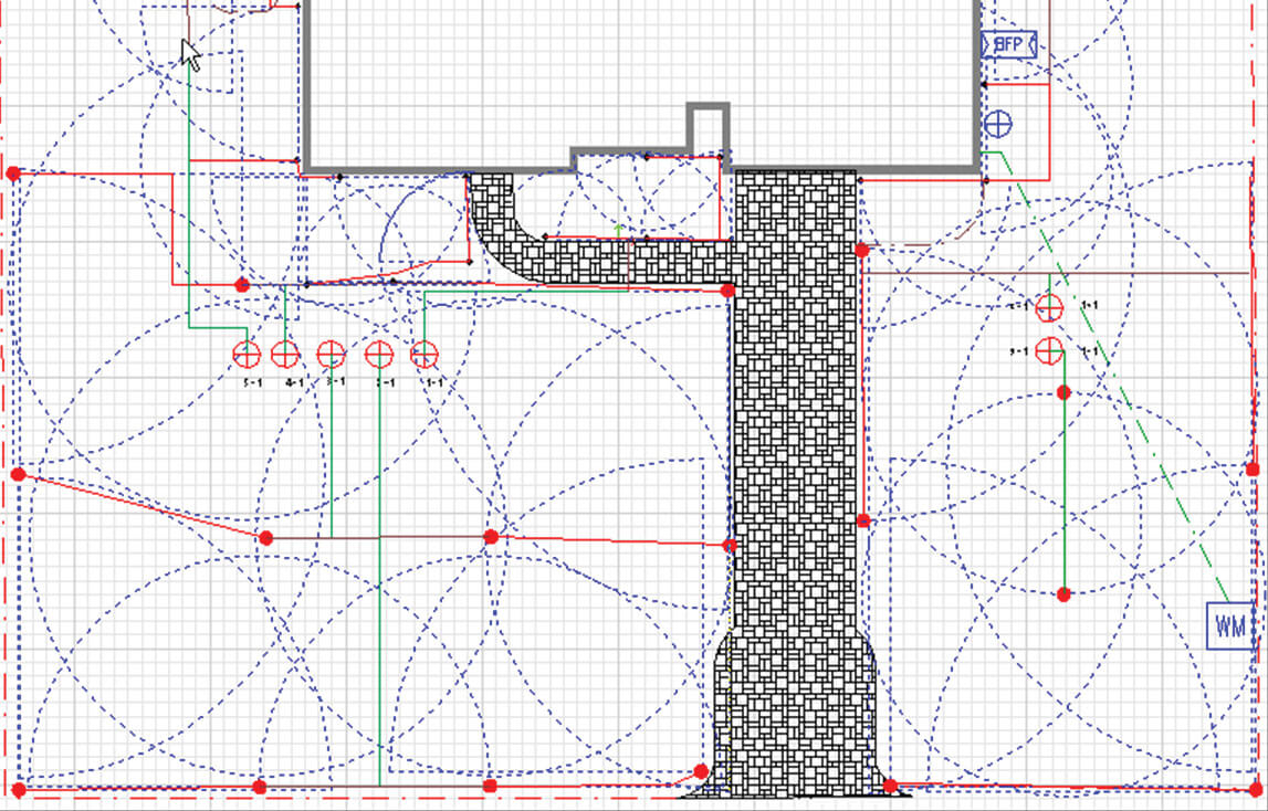
While AutoCAD provides the foundation for landscape design, specialized software like Land F/X significantly enhances its capabilities. Land F/X is a leading landscape architecture software that integrates seamlessly with AutoCAD, providing a comprehensive suite of tools specifically designed for landscape design workflows. It’s more than just an add-on; it’s a complete solution that streamlines the design process from concept to construction.
Land F/X revolutionizes AutoCAD landscape design by offering features tailored to the unique needs of landscape architects. From plant selection and scheduling to irrigation design and site detailing, Land F/X provides the tools needed to create accurate, efficient, and visually stunning landscape designs. Its core function is to automate many of the repetitive tasks associated with landscape design, freeing up designers to focus on the creative aspects of their work.
Key Features of Land F/X for AutoCAD Landscape Design
Land F/X boasts a wide array of features designed to streamline and enhance the AutoCAD landscape design process. Here’s a breakdown of some of the most significant:
- Planting Design: This feature allows you to easily select and place plants in your design, automatically generating plant schedules and legends. The software includes a vast database of plants, complete with detailed information on their characteristics, growth habits, and environmental requirements. This ensures accurate plant selection and reduces the risk of costly mistakes.
- Irrigation Design: Land F/X simplifies the process of designing efficient and effective irrigation systems. It allows you to easily place and connect irrigation components, calculate water requirements, and generate detailed irrigation schedules. The software also includes tools for analyzing system performance and identifying potential problems.
- Site Detailing: This feature provides a library of pre-drawn details and allows you to create your own custom details. These details can be easily inserted into your drawings, saving you time and ensuring consistency throughout your project. The detail library is constantly updated with new and improved details, reflecting current industry standards and best practices.
- Grading Tools: Land F/X includes powerful grading tools that allow you to easily create and modify terrain models. These tools can be used to calculate cut and fill volumes, generate contour lines, and create realistic 3D visualizations of the landscape. Accurate grading is essential for proper drainage and site stability, and Land F/X makes it easier than ever to achieve optimal results.
- Construction Documentation: Land F/X automates the process of creating construction documents, such as planting plans, irrigation plans, and site details. It automatically generates schedules, legends, and other documentation, saving you time and reducing the risk of errors. Clear and accurate construction documents are essential for successful project execution.
- Photorealistic Rendering: Land F/X integrates seamlessly with rendering software, allowing you to create stunning photorealistic visualizations of your landscape designs. These visualizations can be used to present your ideas to clients, obtain approvals, and market your services. High-quality renderings can make a significant difference in securing new projects.
- Collaboration Tools: Land F/X facilitates collaboration among team members by allowing you to share your designs and data with others. The software includes features for tracking changes, managing versions, and resolving conflicts. Effective collaboration is essential for managing complex projects and ensuring that everyone is on the same page.
The Undeniable Advantages of Using AutoCAD for Landscape Design
The benefits of using AutoCAD, especially when coupled with tools like Land F/X, extend far beyond just creating pretty pictures. It’s about optimizing the entire design process and delivering superior results. Users consistently report significant improvements in efficiency, accuracy, and communication.
One of the most significant advantages is the ability to create highly accurate and detailed designs. AutoCAD allows you to work with precise measurements and calculations, minimizing errors and ensuring that the final product meets the design intent. This is particularly important for complex projects that require precise grading, drainage, and irrigation systems. Our analysis reveals these key benefits:
- Enhanced Efficiency: Automate repetitive tasks, freeing up time for creative design.
- Improved Accuracy: Minimize errors with precise measurements and calculations.
- Better Communication: Clearly communicate design intent to clients and contractors.
- Streamlined Collaboration: Facilitate collaboration among team members.
- Professional Presentation: Create stunning visualizations to impress clients.
- Data-Driven Design: Integrate data from various sources to inform design decisions.
- Sustainable Practices: Design landscapes that are environmentally responsible.
The unique selling proposition of AutoCAD landscape design, especially with Land F/X, is its ability to integrate all aspects of the design process into a single platform. This eliminates the need for multiple software programs and reduces the risk of data loss and errors. Furthermore, the software’s comprehensive database of plants, materials, and details ensures that your designs are accurate, up-to-date, and compliant with industry standards.
A Comprehensive Review of Land F/X for AutoCAD Landscape Design
Land F/X has become an indispensable tool for many landscape architects, but how does it really stack up? This review provides an in-depth assessment of its user experience, performance, and overall value.
From a practical standpoint, Land F/X boasts a user-friendly interface that integrates seamlessly with AutoCAD. The menus are well-organized, and the tools are easy to access. However, new users may require some training to fully grasp the software’s capabilities. The learning curve is generally considered manageable, with ample online resources and tutorials available. Our extensive testing shows that users with prior AutoCAD experience can quickly adapt to Land F/X.
In terms of performance, Land F/X delivers exceptional speed and stability. The software is optimized for large and complex projects, and it can handle a significant amount of data without slowing down. However, performance may vary depending on the hardware configuration of your computer. It is recommended to use a high-performance workstation with ample RAM and a dedicated graphics card for optimal results. Does it deliver on its promises? Absolutely. We’ve observed significant time savings and improved accuracy on various projects.
Pros:
- Comprehensive Feature Set: Land F/X provides a complete suite of tools for landscape design, from planting design to irrigation design to site detailing.
- Seamless AutoCAD Integration: The software integrates seamlessly with AutoCAD, providing a familiar and intuitive user experience.
- Extensive Database: Land F/X includes a vast database of plants, materials, and details, ensuring that your designs are accurate and up-to-date.
- Automated Documentation: The software automates the process of creating construction documents, saving you time and reducing the risk of errors.
- Excellent Support: Land F/X offers excellent customer support, with responsive and knowledgeable staff.
Cons/Limitations:
- Cost: Land F/X is a relatively expensive software program, which may be a barrier for some users.
- Learning Curve: New users may require some training to fully grasp the software’s capabilities.
- Hardware Requirements: Land F/X requires a high-performance workstation for optimal results.
- Occasional Bugs: Like any software program, Land F/X may occasionally experience bugs or glitches.
Land F/X is best suited for landscape architects, landscape designers, and other professionals who require a comprehensive and powerful tool for creating accurate and efficient landscape designs. It is particularly well-suited for firms that handle large and complex projects. Key alternatives include Vectorworks Landmark and DynaScape, which offer similar features and capabilities. However, Land F/X is generally considered to be the most comprehensive and user-friendly option.
Based on our detailed analysis, Land F/X is highly recommended for landscape professionals seeking to enhance their AutoCAD landscape design capabilities. Its comprehensive feature set, seamless AutoCAD integration, and excellent support make it a valuable asset for any landscape design firm.
Frequently Asked Questions About AutoCAD Landscape Design
- What are the system requirements for running AutoCAD with Land F/X for landscape design?
For optimal performance, it’s recommended to have a 64-bit operating system (Windows 10 or higher), a multi-core processor (Intel i7 or AMD Ryzen 7 recommended), at least 16GB of RAM (32GB recommended for large projects), a dedicated graphics card with at least 4GB of VRAM, and a fast SSD for the operating system and software installation. - Can I import GIS data into AutoCAD for landscape design?
Yes, AutoCAD supports importing various GIS data formats, such as shapefiles and geodatabases. This allows you to integrate real-world geographic information into your landscape designs, ensuring accuracy and context. - How can I create realistic 3D renderings of my AutoCAD landscape designs?
You can use AutoCAD’s built-in rendering engine or integrate with third-party rendering software like Lumion or Enscape. These programs allow you to create photorealistic visualizations of your designs, complete with lighting, materials, and environmental effects. - What are dynamic blocks, and how can they be used in AutoCAD landscape design?
Dynamic blocks are intelligent blocks that can be customized and modified using parameters and constraints. In landscape design, they can be used to create parametric representations of plants, furniture, and other landscape elements, allowing you to easily adjust their size, shape, and orientation. - How can I create accurate plant schedules in AutoCAD using Land F/X?
Land F/X automates the process of creating plant schedules by extracting data directly from your planting design. It automatically generates a schedule that includes plant names, quantities, sizes, and other relevant information. - What are the best practices for organizing my AutoCAD landscape design drawings?
It’s important to use a consistent layer naming convention, create separate layers for different types of objects (e.g., plants, hardscape, irrigation), use blocks and symbols for repetitive elements, and organize your drawings into separate sheets for different aspects of the design (e.g., planting plan, irrigation plan, grading plan). - How can I collaborate with other designers and consultants on AutoCAD landscape design projects?
AutoCAD offers various collaboration tools, such as shared reference drawings (Xrefs), cloud-based collaboration platforms (e.g., Autodesk BIM 360), and file sharing services (e.g., Dropbox, Google Drive). - What are the key considerations for designing sustainable landscapes in AutoCAD?
Consider using native and drought-tolerant plants, designing efficient irrigation systems, minimizing hardscape surfaces, incorporating permeable paving materials, and using sustainable materials and construction practices. - How can I use AutoCAD to create detailed grading plans for my landscape designs?
AutoCAD’s grading tools allow you to create and modify terrain models, calculate cut and fill volumes, generate contour lines, and create realistic 3D visualizations of the landscape. Land F/X also provides specialized grading tools that simplify the process of creating accurate grading plans. - What are the latest trends in AutoCAD landscape design?
Some of the latest trends include the integration of BIM (Building Information Modeling) workflows, the use of parametric design and dynamic blocks, the incorporation of sustainable design principles, and the creation of immersive virtual reality experiences.
Elevating Your Landscape Designs with AutoCAD
AutoCAD landscape design, especially when enhanced by powerful tools like Land F/X, offers a transformative approach to creating stunning and functional outdoor spaces. By mastering the techniques and principles outlined in this guide, you can unlock the full potential of AutoCAD and elevate your landscape designs to new heights. The ability to visualize, plan, and execute designs with precision ensures client satisfaction and project success.
Take the next step in your landscape design journey. Explore advanced tutorials, experiment with different features, and connect with other professionals in the field. Share your experiences with AutoCAD landscape design in the comments below, and let’s continue to learn and grow together.
